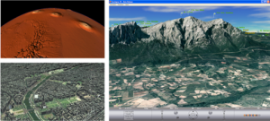
CRS4 made a significant contribution to the advancement of geospatial data visualization techniques by introducing a number of state-of-the-art models and GPU-accelerated methods in the early 2000s. These models and methods have been very well received by the scientific community and have led to numerous follow-ups. The open-source software for rendering terrains on a planetary scale developed by CRS4 has been used for the exploration of very challenging spatial datasets (for example, data on Mars collected by the MOLA (Mars Orbiter Laser Altimeter) tool and displayed interactively for the first time in 2004) and for the realization of one of the first widely distributed regional geoviewing systems: Sardinia 3D (installed by hundreds of thousands of users at its launch in 2006).
The work is described in many publications. The first coarse grained
multi-resolution methods at local and planetary scale were introduced in
the following articles:
- Paolo Cignoni, Fabio Ganovelli, Enrico Gobbetti, Fabio Marton, Federico Ponchio, and Roberto Scopigno. BDAM - Batched Dynamic Adaptive Meshes for High Performance Terrain Visualization. Computer Graphics Forum, 22(3): 505-514, September 2003.
- Paolo Cignoni, Fabio Ganovelli, Enrico Gobbetti, Fabio Marton, Federico Ponchio, and Roberto Scopigno. Planet-Sized Batched Dynamic Adaptive Meshes (P-BDAM). In Proceedings IEEE Visualization. Pages 147-155. IEEE Computer Society Press, October 2003.
Many follow-ups resulted from these two works. In particular, the
methods were then refined to introduce state-of-the-art compression
solutions with tolerance guarantees:
- Enrico Gobbetti, Fabio Marton, Paolo Cignoni, Marco Di Benedetto, and Fabio Ganovelli. C-BDAM - Compressed Batched Dynamic Adaptive Meshes for Terrain Rendering. Computer Graphics Forum, 25(3): 333-342, September 2006. Proc. Eurographics 2006.
Pure terrain rendering was then complemented with specialized solutions
for urban models:
- Paolo Cignoni, Marco Di Benedetto, Fabio Ganovelli, Enrico Gobbetti, Fabio Marton, and Roberto Scopigno. Ray-Casted BlockMaps for Large Urban Models Visualization. Computer Graphics Forum, 26(3): 405-413, September 2007. Proc. Eurographics 2007